Hi Everyone,
I'm in Chicago visiting my daughter Natalie. She's working tonight, Milo's at the baby-sitter's 'till 9, I have a few hours to reminisce and write.
-------------------------------------------------------------------------------------------------------------
The road into Casper, Wyoming is very interesting - very interesting indeed.
I'm at mile 4850 of my 6000 mile odyssey and my Honda Odyssey is sitting perfectly still in the northbound lane of WY-220, a paved two-lane highway that roughly follows the trail blazed by the pioneers. Dale Eckhardt, our loving Curly friend through all the Curly years, has told me to try to stop at Martin's Cove, Devils Gate and Independence Rock on the way to her home in Casper. "Very interesting places," she says. "The pioneers wrote their names on Independence Rock," she says."Very interesting."
Traveling east out of San Francisco you pass through the Sierra Nevada mountains along the Donner Pass. Talk about creepy places. The terrain is absolutely exquisite. [I relearned that word watching Sesame Street with my grandson Milo this morning - I digress.] Snow capped mountains towering above lush green forests. Signs along the highway are the only man-made objects other than the highway itself. Donner Memorial State Park, Donner Pass Road, etc.. Along this ribbon of exquisitely carved concrete people struggled and died and .... I'm cruising it at 75 mph while imagining - no - not imagining. I'll focus on the highway. I'll play some music. This place is weird. Let me out of here!
Motoring across the Great Salt Lake dessert I think to myself that I haven't seen a single wild animal since leaving California. Here, now, somewhere on a great southeast Wyoming plateau, I'm gazing west across endless prairie in breathless amazement at a band of a dozen or so wild horses streaking across the far horizon in single file, moving ever so slightly closer and closer as I accelerate slowly to 10 mph. I'm syncing the pace of the Odyssey to their pace. 15 mph. They're getting closer, I can see each horse clearly now, long flowing manes and tails flying, wishing I had my camera. No, bad idea. 20 mph, they're in a stiff trot, perhaps 100 yards away, the light gray lead stallion throws his magnificent head back and suddenly disappears. What! Then the next horse, then the next - gone! Down into a deep, narrow ravine that runs along the other side of the highway. Must be water in it. They're gone. Never got a picture. Wow! I can't believe it!
Down the road is a heard of over 100 Pronghorn Antelope, their fluffy white rear ends fluttering like flowers in the harsh Wyoming wind. I hardly slow down. Oh yes, it's windy, cold and raining, the temperature frequently drops below freezing. Heavy clouds hang down from the heavens to within a couple hundred feet of the ground. A cold, hard rain drenches everything. The highway before me clear and wet, the mountains around me have have their tops clipped off by the clouds. Things have a way of disappearing around here. Ahead is the turnoff for Martin's Cove.
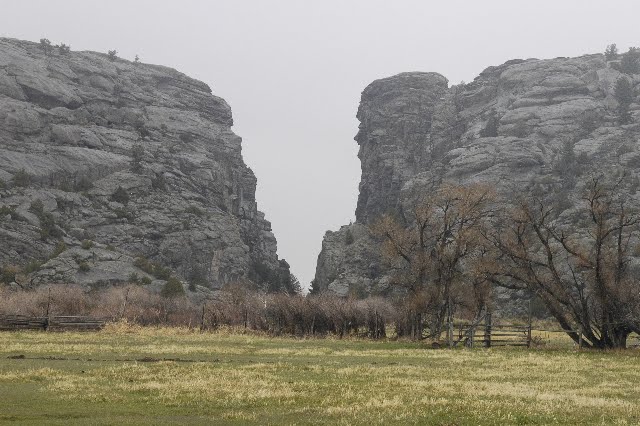
Once again the Odyssey has stopped still on the narrow dirt road leading to Martin's Cove. I'm trying to reconcile what I'm seeing with my mental model of this place. There's a dirt road beneath me, opaque clouds above me, in front of me, perhaps a few miles away is a mountain, its summit concealed by the clouds, extending as far left and right as I can see, an impenetrable barrier blocking my path. Except... Except for a huge vertical V-shaped cut neatly cleaving the impenetrable mountain into two, like the horizontal wedge shaped cut of the lumberjacks axe that fells the tree. "Devil Gate," I mumble. As I inch forward I see cabins and people and signs of civilization from 150 years ago. Martin's Cove. I park in the first spot I see.
After donning my down parka and letting Orion and Rosie out of the Odyssey we are met by Ranger Rick. No, that's not his real name. But he's wearing an olive brown uniform that has a patch that looks official. He offers us the shelter of his ranger cabin to answer questions we might have about this place, which seems a little odd, since I'm the only one capable of asking questions, but I guess he's used to speaking plurally to groups, given the number of log benches in his cabin. Orion and Rosie really like Ranger Rick, they rub against him as he unconsciously strokes them while delivering his Ranger Rick talk about the handcart people. On one wall of the cabin is a large map titled "Trail of The Martin Handcart Company."

"It was here that 150 brave Mormon pioneers of the Martin company perished, but 600 were rescued when a violent snowstorm stranded them at this very spot." I ask him if the Mormon trail went through Devils Gate. "Too narrow, can't get wagons through," he replies. I notice the map has a big red "You Are Here Arrow" that immediately confuses me as to where I am and what direction I am pointed and I feel disoriented and confused and now I am in my down parka in a log cabin 150 years ago. Outside, I can hear people crying and moaning, dragging all their earthly possessions in heavy carts, up the mountains and across the river, freezing, starving, exhausted from exhaustion. Then they see it, Devils Gate. It mocks them, for it is too narrow for them to pass through. It is the final blow. They can go no further. They are doomed. My mind swirling, reason strikes. You're doing it again. Don't imagine it, don't imagine it... "Thank you for your very interesting information and allowing us out of the rain," I say to Rick as we scurry out the door. "No dogs in the visitor's center," he replies.

I drive the direction Rick has pointed out. The road follows the pioneer's path along the flank of a the huge monolithic mountain miles across, neatly cleaved by the Devil's Gate, and as we drive up and around the mountain and Devils Gate narrows until it finally disappears we are drawn up and forward as if by an invisible force and there are crosses and grave markers by the side of the dirt road and the Odyssey speeds up all by itself and there are huge rocks hanging threateningly over the road and the Odyssey wants to get out of that place and it drives fast until it sees WY-220 and then it stops.

And I suddenly remember that this entire time I haven't gotten a single picture. So I make a U-turn on the highway and head back into the inferno and I realize that only now am I traveling the same direction as the handcarters and they would not have seen Devil's Gate until they had gone past it by several miles. I had been playing the movie backwards. Such is the power my delusion. I feel relieved. I drive back to Martin's Cove, get out my camera and shoot a few pictures, drive back past monolithic mountain, shoot a few more pictures, than quickly depart to the safety of WY-220.
Just a few miles down the road is Independence Rock, a gigantic round mound of granite bearing the inscribed names of pioneers who endeavored to reach this point of the Oregon Trail by Independence Day in order to safely make it through the mountains before the snowfall. The rock is a half mile from the parking lot. We are wet and freezing as we approach the massive lump of stone. Not a single inscription is visible. We walk all around the rock, over a mile. Nothing. Not a single name. Then I spot a single inscription, high up the stone's steeply sloping face. It's been scratched on the rock, visible only because the stone is somewhat dry here. Elsewhere, the rock's wetness conceals its historic scratched graffiti. Yet another disappearing trick.


Highway WY-220 runs right into Casper. Keep going straight, turn right at Ash street, and I'm parked in front of Dale's house. She's standing on the front steps, grinning. I hesitate a few moments, making certain that she doesn't disappear.
More Wyoming adventure as soon as time allows.
Stan